

C
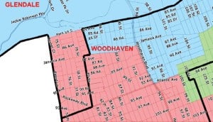
Woodhaven, which had been united in one district is the first draft of redistricting, is divided again at Forest Parkway and 80th Street, with much of the neighborhood moving into a different district.

Posted: Thursday, November 29, 2012 10:30 am
The latest draft of new City Council district maps that may be the final lines for the next decade, should they be approved, are raising eyebrows, and tempers.
The new maps are the final drafts proposed by the NYC Districting Commission and have been submitted to the City Council, which can approve or reject the proposal by Dec. 7. If no action is taken by the council, the maps are deemed approved.
But pressure is mounting from across the borough — and the city as a whole — for the council to reject the maps and force the NYC Districting Commission back to the drawing board.
The new maps make some key changes from the first draft, notably uniting communities like Maspeth, LeFrak City and Cambria Heights, that had been split under the first draft, while dividing other communities such as Woodhaven, North Flushing and Fresh Meadows, that were united. Some neighborhoods, such as Briarwood, are completely upended and moved into a different district.
The new maps were met with stiff opposition from interest groups and civic leaders, who say the commission did not take communities and demographics into considering when drawing the draft maps.
The Asian American Community Coalition on Redistricting and Democracy is among those blasting the commission’s final draft.
ACCORD criticized a number of the commission’s decisions, including keeping Oakland Gardens and Bayside in two separate districts. Much of Bayside north of Northern Boulevard remains in District 19, while Oakland Gardens is in the 23rd District.
“The residents of Oakland Gardens often identify themselves as living in Bayside,” said James Hong, ACCORD’s representative at the Oct. 10 Queens hearing of the NYC Districting Commission.
But the unification of Bayside and Oakland Gardens was opposed by one of the commission members — former state Sen. Frank Padavan — who represented Bayside in Albany for over 30 years.
The main argument against its unification are the different demographics between the two sections of the neighborhood. Oakland Gardens is mainly a middle-class Jewish and Asian area where most residents live in apartments or condominiums, while Bayside is mostly a white, Christian area, but with a large Asian-American population who live mostly in detached one- and two-family homes.
The MinKwon Center for Community Action, a Flushing-based Asian-American advocacy organization working with ACCORD, slammed the rationale and asked for the City Council to reject the maps.
“Anyone attending the Queens public hearings knew that the community fully supported a united Bayside, with Oakland Gardens as part of it,” said Steven Choi, executive director of the MinKwon Center. “We call on the City Council to take responsibility: the Commission has failed the people of New York City and so the City Council needs to act.”
ACCORD did say it approved of the unification of Elmhurst, home to a growing Asian-American population, into one district.
One of the neighborhoods most affected by the new draft map is Woodhaven, which was completely united into a district represented by Elizabeth Crowley (D-Middle Village) in the first draft of the map. Now, it is divided again, roughly at Forest Parkway, with the west side moving into Crowley’s district and the east side into the district of Eric Ulrich (R-Ozone Park).
Under the existing map, drawn after the 2000 Census, the western side of Woodhaven is represented by Ulrich and the eastern side with Richmond Hill is in Crowley’s.
Woodhaven Residents’ Block Association President Ed Wendell is urging the Woodhaven’s two council members to reject the proposal when it comes before a vote in the City Council.
“This is an opportunity for City Council Members — both our current representatives, as well as those who might want Woodhaven’s support in the future — to show whether they actually care about our community,” he said in a statement.
A number of changes were made to District 28, represented by Councilman Ruben Wills (D-South Jamaica). Though Rochdale Village remains in the district, the western border is moved from Lefferts Boulevard to 103rd Street in Ozone Park, uniting all of South Richmond Hill in the district and forcing the elimination of portions of South Jamaica and Springfield Gardens.
But Vishnu Mahadeo, president of the Richmond Hill South Economic Development Council, said the commission was discussing an alteration to the maps with the border between the districts being at 112th Street, dividing South Richmond Hill again.
Mahadeo said the goal was to eliminate the Lefferts boundary and unite the neighborhood. Although the new maps do that, the proposal does not go far enough to unite the community.
“It’s a small investment in the Richmond Hill area, they haven’t done much,” he said. “It means that Richmond Hill has been dealt a bad hand yet again.”
He noted that Ulrich, who represents the western half of the neighborhood has been far more responsive to their needs than Wills because Richmond Hill does not have the political clout to challenge him.
Mahadeo said the maps also continue to divide the community from Richmond Hill north of Atlantic Avenue, further diluting the community’s influence. That, he warned, often leads to low voter turnout.
“It takes away the opportunity for the community to get a proper response,” he said. “If you don’t vote as a whole, what will happen is that community will lose out. People are not going to be motivated to come out and vote when they are fragmented.”
The maps also divide South Ozone Park at Lefferts Boulevard, which is unchanged from the previous decade.
“The large Asian American community in South Ozone Park continues to be split in half along Lefferts Boulevard between Districts 28 and 32,” said Richard Davis, executive director of the Indo-Caribbean Alliance. “While the changes in Richmond Hill are promising, our community’s advancement will be significantly constrained due to the division of South Ozone Park.”
The maps have also caused a stir among residents of North Flushing, who question why the border between the 19th and 20th districts, which had previously been north of the Mitchell-Linden complex and now runs along 33rd Avenue. Some have asked why 33rd Avenue — a mostly residential side street — was used as the district border, rather than the larger Northern Boulevard a few blocks south which provides a barrier between North Flushing and the more densely populated, homogeneously Asian-American part south of Northern Boulevard.
The maps have also drawn accusations of incumbent protection, which sparked up after the commission’s executive director, Carl Hum, said incumbents and their relationships to constituents were taken as a “legitimate concern” by the drawing body.
“If relationships matter, why did they basically switch the parts of Woodhaven Elizabeth Crowley and Eric Ulrich represent?” asked WRBA spokesman and Community Board 9 member Alexander Blenkinsopp.
Another Queens member of the commission is Tom Ognibene, a former councilman who held Crowley’s seat and served as minority leader and is a political ally of Ulrich.
Though some have accused the commission of being politically motivated while drawing the maps, Council Speaker Christine Quinn, a likely mayoral candidate next year, has denied those claims.
The council has until Dec. 7 to approve or reject the maps, or do nothing, which will automatically make them law.