Main Ridge, Tobago -- Trinidad and Tobago
From Wikipedia, the free encyclopedia -- https://en.wikipedia.org/wiki/Main_Ridge,_Tobago
Main Ridge is the main mountainous ridge on the island of Tobago, Trinidad and Tobago. Running from southwest to northeast between the Caribbean Sea and the Southern Tobago fault system. The Main Ridge Forest Reserve, which was legally established in 1776, is one of the oldest protected areas in the world. It is an important site for birdwatching and ecotourism. Main Ridge provides important habitat for native plants and animals, including several species endemic to Tobago.
| Main Ridge | |
|---|---|
| Highest point | |
| Elevation | 572 metres (1,877 ft) [1] |
| Geology | |
| Mountain type | Fault-block mountain |
| Type of rock | Schist |
History
The Treaty of Paris in 1763 ended Tobago's status as a neutral territory and made it a British colony.[2] The Treaty of Aix-la-Chappelle in 1748 had designated Tobago neutral territory and left it in the hands of its remaining indigenous population, but the return to British control led to a rapid conversion of the island to a plantation economy.[3]:127–128 Under the direction of the Board of Trade,[2] the island was surveyed, divided into 100–500 acres (40–202 ha) plots, and sold to planters.[3]:127–128 The upper portions of the Main Ridge were reserved as "Woods for the Protection of the Rains" and thus remained uncleared and uncultivated.[2]
The decision to preserve forests to maintain rainfall was driven by the efforts of Soame Jenyns, a commissioner of the Board of Trade and Member of Parliament. Jenyns was convinced of the importance of forests for preserving rainfall through the work of Stephen Hales on plant physiology and transpiration.[4]:273–274 It took Jenyns eleven years to convince the British Parliament of the importance of the endeavour, but on 13 April 1776, Parliament passed an ordinance establishing the reserve "for the purpose of attracting frequent showers of rain upon which the fertility of lands in these climates doth entirely depend".[5] This action produced one of the oldest protected areas in the world geared towards conservation[5][6] and has been described as "the first act in the modern environmental movement".[5]
Beginning in 1904, the rain reserve was combined with adjacent Crown lands and proclaimed the Main Ridge Forest Reserve.[7]
Geography
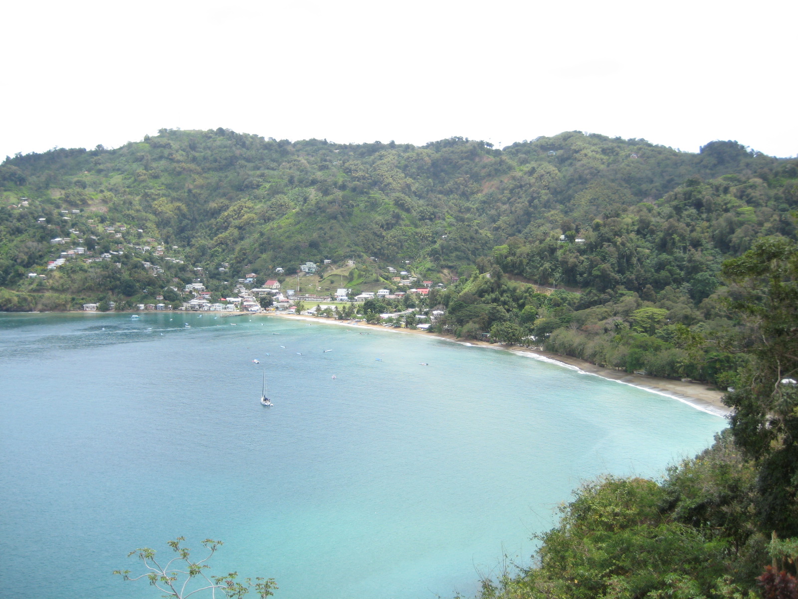
The hills of the Main Ridge meet the sea along Tobago's north coast.
Main Ridge forms the mountainous backbone of the island of Tobago, which is the smaller and more northern of the two main islands that make up the Republic of Trinidad and Tobago in the southern Caribbean.[1] The chain of hills are 29 kilometres (18 mi) long[8] and runs from the southwest to the northeast,[9] roughly parallel to the orientation of the island.[7] Main Ridge reaches an elevation of 572 metres (1,877 ft) above sea level[1] but lacks any well-defined peaks.[7] To the northwest it is bounded by the Caribbean Sea and by the Southern Tobago fault system to the southeast.[1]
Rainfall averages about 2,800 millimetres (110 in) per year.[10]:5 Most streams run along oblique-slip faults with a northwest orientation. Major streams draining the Main Ridge include the Coffee, Hillsborough, Goldsborough, and Queens Rivers. Streams which drain to the northwest are short and steep, while those which drain to the southeast are longer, with better-developed courses. Waterfalls, including the Argylle Waterfall (Tobago's highest) occur at major transitions between rock types.[1]
Geology
Main Ridge is primarily underlain by the metavolcanic North Coast Schist Group.[11] The underlying igneous rock was laid down during the Late Jurassic or Early Cretaceous, and underwent metamorphosis prior to the mid Cretaceous, when additional volcanic intrusion formed the rocks of the Tobago Volcanic Group. A combination of uplift, erosion and faulting during the late Mesozoic and Paleogene,[12] led to the elevated horst block separated from the half graben of the southern lowlands by the Southern Tobago fault system.[1]
Vegetation and ecology
Main Ridge is dominated by lower montane rain forest[13] (according to John Stanley Beard's classification of the vegetation of Tobago).[7] In Tobago, these forests are characterised by an emergent canopy of Licania biglandulosa and Byrsonima spicata,[7][13] with the palm Euterpe broadwayi more common on exposed ridges and summits.[7] Moist lowland forest dominates the lower-lying portions of the Main Ridge.[8] The forests experienced limited human disturbance prior to the 1940s,[7] but were badly damaged by Hurricane Flora in 1963.[10]
Conservation
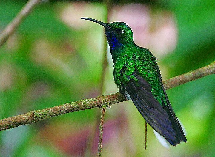
White-tailed sabrewing photographed at Gilpin Trace, Main Ridge.
The Main Ridge Forest Reserve, a 3,937-hectare (9,730-acre) forest reserve, is one of the oldest protected areas in the world.[6] The Trinidad and Tobago government submitted the Main Ridge Forest Reserve as a tentative listing for a UNESCO World Heritage Site in 2011.[5][14] The area is managed by the Department of Natural Resources and the Environment, a department of the Tobago House of Assembly.[15]
The Main Ridge Forest Reserve plays an important role in the protection of native biodiversity, particularly endemic plant species.[16] The Main Ridge is one of two areas in the country which support the most globally rare plant species.[8] A gap analysis of endemic vascular plants of Trinidad and Tobago identified 15 endemic plant species in the area; species distribution modelling suggested that the reserve included suitable habitat for another nine plant endemic species.[17]
Main Ridge provides critical habitat for two endemic amphibians, Pristimantis turpinorum (Turpin's frog) and Mannophryne olmonae (Bloody Bay tree frog), which are endemic to northeastern Tobago[6] and for the coral snake mimic Erythrolamprus pseudoreginae.[9] The white-tailed sabrewing (Campylopterus ensipennis) is endemic to northeastern Venezuela and the Main Ridge; after Hurricane Flora in 1963 the hummingbird was thought to be extirpated from Tobago, but was rediscovered in 1974.[18] Plant species endemic to Tobago which have been recorded from the Main Ridge include Odontonema brevipes, Duguetia tobagensis, Phyllanthus acacioides, Besleria seitzii, Cybianthus pittieri, Pilea tobagensis, and Justicia tobagensis.[16]
Ecotourism
Main Ridge is an important ecotourism destination,[6][15] and birdwatching site.[19] The site has a visitor centre and a network of nine trails which allow access to the site. Additional trails were constructed to reduce pressure on the most popular trail Gilpin Trace, which is prone to over-use.[15] The Main Ridge Forest Reserve was named the World’s Leading Ecotourism Destination by the World Travel Awards from 2003 to 2006, and the World’s Leading Green Destination in 2007 and 2009.[20]
Threats
Forests on the Main Ridge were damaged by Hurricane Flora in 1963 and its forests continue to be susceptible to hurricane damage. Given the small size of the area, fires started in surrounding agricultural lands can penetrate deep into the hills.[16] Commercial and subsistence hunting and overuse for tourism pose threats to biodiversity, while the chytrid fungus Batrachochytrium dendrobatidis poses a threat to endemic amphibians.[6]
Source & References - https://en.wikipedia.org/wiki/Main_Ridge,_Tobago