New Venezuelan decree claims ownership over Guyana’s continental shelf
By Odeen Ishmael
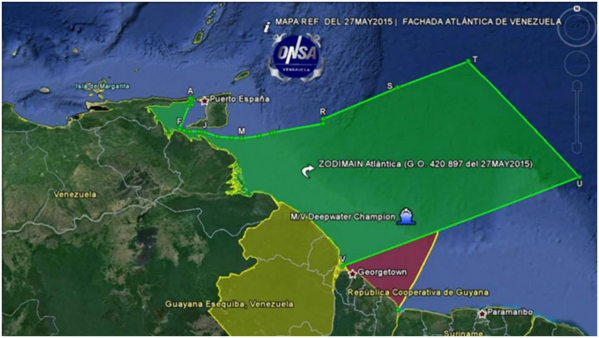
Venezuela’s President Nicolas Maduro on May 27 issued a decree creating the “Atlantic coast of Venezuela” which now includes sovereignty over Guyana’s territorial waters in the Atlantic Ocean off the Essequibo region. A map, issued to coincide with this decree, indicates that Venezuela is now claiming all the territorial waters within the 200 miles range and blocking Guyana’s access to its resources in this area of the Atlantic Ocean.
This new extension of Venezuela’s claim to Guyanese territorial waters was made official in the presidential decree, No. 1787, and published in the Ordinary Official Gazette No. 40,669, dated May 27, 2015. It is the second decree expressing a claim to Guyana’s territorial waters; the first, issued by President Raul Leoni forty-seven years ago in July 1968, purportedly claimed “sovereignty” over a twelve-mile strip of Guyana’s continental shelf along the Essequibo coast.
The Maduro decree is set amid Venezuela’s objection over oil exploration and concessions granted by Guyana to the US oil company, Exxon-Mobil, to explore 23,000 square kilometers of the Stabroek Block located within the area into which the new territorial claim is now extended. Earlier this year when Exxon-Mobil was about to drill an exploratory well in the area, Venezuela claimed the drilling area as part of its territorial sea. The oil company recently announced a significant discovery of hydrocarbons in the drilling area.
By this decree, the Venezuela government has also created the so-called “Areas of Integral Defense of Marine Zones and Islands,” thus ratifying its maritime sovereignty over the waters of the parts of the Caribbean and off the coast of Guyana. In doing so, it now claims sovereignty over the continental shelf and a projection of the Atlantic Ocean off the Essequibo region of Guyana, and even stretching into part of Suriname’s maritime space.
Commenting on this latest move by her government, Foreign Minister Delcy RodrÍguez, according to the June 5 issue of the Venezuelan paper, El Estimulo, said it was aimed at the “defense of the Essequibo.”
The ONSA map showing the new Venezuelan claim (shown in green)
As a follow-up to the latest decree, a map showing the new claim was prepared by the National Organization for Maritime Safety (ONSA), a non-governmental organization comprising merchants, sports and retired naval officers. According to Commodore Nicolas Goshenko, the chairman of ONSA, the new map was made under the coordinates provided by the Venezuelan government as stipulated the presidential decree. Saying that his country’s claim to the area must be defended, he added that ONSA acted independently in creating the map showing a claim to almost all of Guyana’s territorial waters.
Goshenko declined to comment on possible actions that could take Guyana with the presidential decree saying, “That’s a problem of Guyana.”
However, diplomatic expert Dr. Sadio Garavini, who served as Venezuela’s ambassador to Guyana in the 1980s, as reported by El Estimulo on June 5, was cautious about the effect of the new decree, and he urged his country’s Foreign Ministry to clarify the scope of the new “Areas of Integral Defense of Maritime Zones and Islands.”
He also wanted to know if the Venezuelan government had notified Guyana of this new situation. This decree is the first major confrontation by the Venezuelan government against the new administration in Guyana which assumed power less than a month ago following the general elections on May 11.
Dr. Odeen Ishmael served as Guyana’s ambassador to Venezuela from 2003 to 2011. He is the author of The Trail of Diplomacy – the Guyana-Venezuela Border Issue (in three volumes.


