10 statistics that place this powerful storm in perspective
Overhyped? Hardly – this storm system is massive and its effects will be felt for days by much of the US east coast

Hurricane Sandy is barreling its way up the Atlantic ocean on its way for a collision course with the northern mid-Atlantic. The storm has set off panic among residents from Washington, DC, to New York City.
You keep hearing meteorologists and public officials use phrases "amazing", "historic", and "never seen" to describe the storm. There's a chance that people view this storm as overhyped. I, however, feel that most of the warnings are well deserved.
Why? Here's a list of 10 statistics that will likely make this storm one to remember.
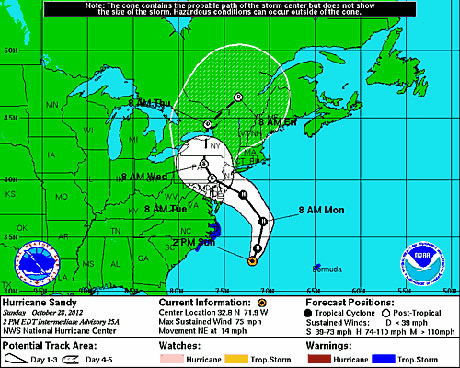
1. 90 degrees – Usually when a storm makes it up to the northern mid-Atlantic latitude, it's already way out to sea. Sandy would do the same thing except there's a giant high pressure in the middle of the Atlantic forcing it to make a sharp 65 degree turn to get up to the southern New Jersey latitude. Then, it will make a 90 degree right turn upon landfall.
 sandy 90 degrees Photograph: Noaa.gov
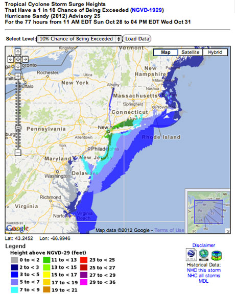
 2. 12 feet – The biggest fear from this storm in the New York City area is the storm surge. Right now anything from 6 to 12 feet seems quite possible. The greatest storm surge in modern history at Battery Park was 10.5 feet in 1960. Irene's storm surge was a little over four feet in New York. That's why you're seeing evacuations in New York.
 Photograph: Noaa.gov
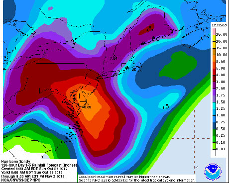
3. Nine inches – The greatest rain amounts will be in southern New Jersey into Delaware and eastern Delaware. We could see half a foot of rain extend from Washington, DC, to Philadelphia. This will lead to flooding all over the place. To put this amount into perspective, six inches of rain is double the Philadelphia October monthly average.
 rainfall sandy Photograph: Noaa.gov
4. 80 miles per hour – We're talking about hurricane force wind gusts into New York City with sustained winds of 50 miles per hour likely. And 40 mile per hour sustained winds are possible all the way from Buffalo, New York, to Boston, Massachusetts, to Washington, DC, to Pittsburgh, Pennsylvania. This will likely cause massive power outages over a wide area.
5. 951 millibars – Sandy's extremely low pressure ensures that the storm will be long lasting, massive in scope, and windy all over the place. The lowest low pressure to ever hit New Jersey was 961 millibars. The pressure in New York City right now is 1007
millibars. Hurricane Isaac, which hit New Orleans earlier this year, had a minimum low pressure of only 968 millibars.
6. Two feet – Most of us are concentrating on the rain and wind, so it's easy to forget that there will be snow with this storm. The mountains of West Virginia above 3000 feet could see one to two feet of snow. There are also likely to be some snowflakes falling into central Ohio, though any accumulations there should be far less.
7. 36 hours – Most storms of tropical origin see their winds diminish quickly upon landfall. Sandy isn't going to stop with tropical storm force winds until well into Wednesday. It may already be near Buffalo at this point. Rainfall over 3+ inches will follow this wind line. Rain could continue in Philadelphia until early Wednesday. That's why we're seeing so many watches and warnings of many different types all over the place.
8. 3000 flights – More than 3,000 airline flights have already been cancelled because airports from Washington to New York are shutting down. Amtrak is also ending service. Even the unflappable New York City public transportation system is closing at 7pm on Sunday. Transportation will be at a standstill in the east.
9. 60 million – Because of all the factors listed above, many people will be affected in one way or another. Students including in New York City will have at least one day off from school. All told 60 million people is about 20% of the United States population.
10. Two years – We're now seeing two years in a row with a hurricane-like system heading into the New York City area. We're also witnessing two years in a row of massive late October storms. Whether I agree with it or not, this will lead to discussion over whether we're witnessing the first impacts of climate change.
