Industrial site, Ruimveldt
Former Member
Former Member
Originally Posted by Django:
Originally Posted by Gilbakka:
Originally Posted by Django:
Originally Posted by Gilbakka:
Sorry I'm late, guys.
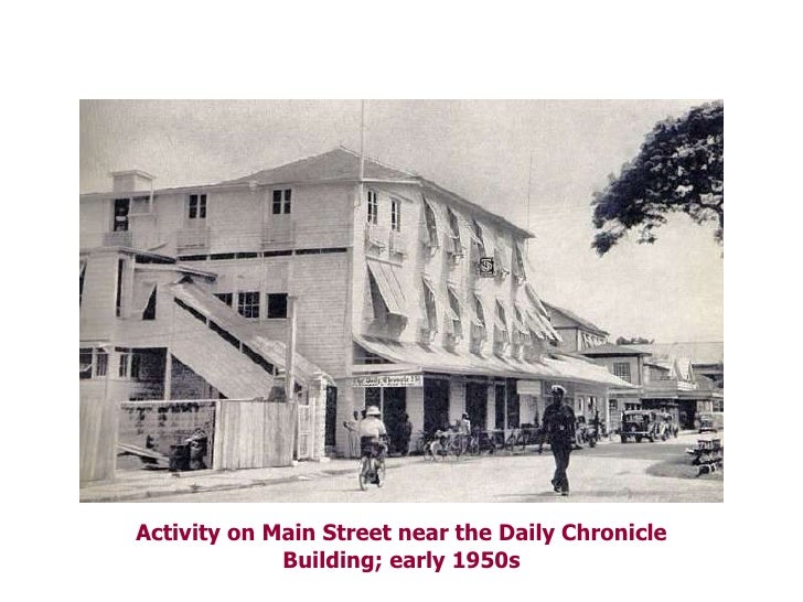
The Chronicle newspaper is printed at Lama Avenue, Bel Air Park, Georgetown. Where was the Chronicle newspaper printed before?
Vlissengen Road
Nah bai.
Bhai how many location that printery change,i got the
answer from this quiz.![]()
April 8, 2015 10:32 AM
Originally Posted by Gilbakka:
Our quiz today:
On Vlissengen Road in Georgetown there are three gas stations side by side. Behind those gas stations there is the Demerara Tobacco Company [DEMTOCO] and after that, the Chronicle newspaper compound.
Now, ignore the gas stations. What had existed on the land now occupied by DEMTOCO and Chronicle, and what major historical event took place there?
Still wrong. Chronicle is the oldest newspaper in Guyana. Burnham took it over from D'Aguiar who had bought it from some colonials. Burnham moved the Chronicle from its original location and settled it on Lama Avenue where the Graphic was printed, two doors from Vlissengen Road.
Try again.
Former Member
Originally Posted by Riya:
Ruimveldt
No. You and Anjali can try again.
Wasn't Chronicle on Main St by Courts?

Former Member
Originally Posted by Mars:
Wasn't Chronicle on Main St by Courts?
I have to be fair here, buddy. I had disqualified Riya for giving an answer in the form of a question. So I will say you're asking the correct question.![]()
Yes, the Chronicle newspaper was printed in Main Street for decades. The building stood opposite Hotel Tower. One trivia: in colonial time the first copies of the Chronicle were rushed to Government House down Main Street for the governor's reading pleasure.
Gil, i think we are re-writing Guyana history on this thread.
keep it up bro.![]()

Former Member
I like the old style building ![]() . Had no idea about the trivia re the colonial times and the paper being rushed to Govt House for the Governor to read. I'm learning history and I love it, thank you Sir Gil for all your effort in doing this, I actually look forward to the questions every morning.
. Had no idea about the trivia re the colonial times and the paper being rushed to Govt House for the Governor to read. I'm learning history and I love it, thank you Sir Gil for all your effort in doing this, I actually look forward to the questions every morning. ![]()
I have wan qestian what is pressa foot? like when people say he is a pressa foot
Originally Posted by Gilbakka:
Originally Posted by Mars:
Wasn't Chronicle on Main St by Courts?
I have to be fair here, buddy. I had disqualified Riya for giving an answer in the form of a question. So I will say you're asking the correct question.![]()
Yes, the Chronicle newspaper was printed in Main Street for decades. The building stood opposite Hotel Tower. One trivia: in colonial time the first copies of the Chronicle were rushed to Government House down Main Street for the governor's reading pleasure.
Sorry sir, I didn't see the rules being published. I thought your quiz show was like Jeopardy where you answer with a question. ![]()
I remember looking up those stairs at the side of the Chronicle Building when I was a child and thinking that they were so many of them.
I think there was a disco up there after Chronicle left. Shabari?
Originally Posted by ball:
I have wan qestian what is pressa foot? like when people say he is a pressa foot
a person who like to impress people.![]()
a hope me answer is correct.![]()
Former Member
The weather is fine today to do some grave-digging.
A British governor is buried in the Officers' Cemetery at Eve Leary/Police Headquarters, Georgetown. What is his full name?
Former Member
General Hugh Lyle Carmichael.
good morning![]()
General,Hugh Lyle Carmichael.
Former Member
Originally Posted by Anjali:
General Hugh Lyle Carmichael.
good morning![]()
Yes! And you might have noticed that Carmichael Street was named after him. He served as Governor of Demerara and Essequibo from 1812 to March 1813 when he died.
You get first prize.
Django gets second prize.
Congrats!!
Former Member
Next quiz.
How old is Georgetown as a city?
Former Member
in April 1812 - so 203 years
Former Member
Originally Posted by Gilbakka:
Originally Posted by Anjali:
General Hugh Lyle Carmichael.
good morning![]()
Yes! And you might have noticed that Carmichael Street was named after him. He served as Governor of Demerara and Essequibo from 1812 to March 1813 when he died.
You get first prize.
Django gets second prize.
Congrats!!
Thank you, Sir Gil.![]()
Originally Posted by Gilbakka:
Next quiz.
How old is Georgetown as a city?
234 years
Former Member
234 years
Former Member
Originally Posted by Gilbakka:
Next quiz.
How old is Georgetown as a city?
No correct answer yet. Read every word in this question.
Originally Posted by Gilbakka:
Originally Posted by Gilbakka:
Next quiz.
How old is Georgetown as a city?
No correct answer yet. Read every word in this question.
173 years
Former Member
1842- so 173 years.
Former Member
173 years
Wow!! 39 pages of brain-tickling!
I peek in every so often to get some of the neat info ![]()

Former Member
Originally Posted by Gilbakka:
Originally Posted by Gilbakka:
Next quiz.
How old is Georgetown as a city?
No correct answer yet. Read every word in this question.
Georgetown officially became a city in August 1842.
In August 2015 the city will be 173 years old.
Today, April 16, Georgetown is 172 years old.
Anyway, Gilbakka is a merciful man.
Django, Anjali and Riya are all winners.
Now, yuh all go and brush up on your subtraction. Don't mek da mistake again. Class dismissed.![]()
Georgetown gained official city status on August 24, 1842, during the reign of Queen Victoria. In 1848, the British built a railroad, five miles (eight kilometers) long, from Georgetown to Plaisance, which was the first railroad on the South American continent.
http://www.newworldencyclopedi...y/Georgetown,_Guyana
I noticed Guyana had the first railroad in South America.
Originally Posted by Villagebelle:
Wow!! 39 pages of brain-tickling!
I peek in every so often to get some of the neat info ![]()
Join us we need the help.![]()
Former Member
Originally Posted by Gilbakka:
Originally Posted by Gilbakka:
Originally Posted by Gilbakka:
Next quiz.
How old is Georgetown as a city?
No correct answer yet. Read every word in this question.
Georgetown officially became a city in August 1842.
In August 2015 the city will be 173 years old.
Today, April 16, Georgetown is 172 years old.
Anyway, Gilbakka is a merciful man.
Django, Anjali and Riya are all winners.
Now, yuh all go and brush up on your subtraction. Don't mek da mistake again. Class dismissed.![]()
Ok Sir Gil, will try not to make that mistake again and thank you.![]()
Former Member
Originally Posted by Django:
Georgetown gained official city status on August 24, 1842, during the reign of Queen Victoria. In 1848, the British built a railroad, five miles (eight kilometers) long, from Georgetown to Plaisance, which was the first railroad on the South American continent.
http://www.newworldencyclopedi...y/Georgetown,_Guyana
I noticed Guyana had the first railroad in South America.
Because dem Spaniards in South America were content to sit on their high horses. Little British Guiana mek dem decide to go for the iron horse/railway.![]()
Originally Posted by Gilbakka:
Originally Posted by Django:
Georgetown gained official city status on August 24, 1842, during the reign of Queen Victoria. In 1848, the British built a railroad, five miles (eight kilometers) long, from Georgetown to Plaisance, which was the first railroad on the South American continent.
http://www.newworldencyclopedi...y/Georgetown,_Guyana
I noticed Guyana had the first railroad in South America.
Because dem Spaniards in South America were content to sit on their high horses. Little British Guiana mek dem decide to go for the iron horse/railway.![]()
Guyana had the first iron horse/railway in South America
and the kabaka get rid of it.![]()
well to remedy duh start wuk wid big people
Former Member
![]()
[Movie --- John Travolta --- Olivia Newton-John --- Disco Dancing]
Today we shall revisit Guyana discos.
Where was The Library disco located?
Originally Posted by Gilbakka:
![]()
[Movie --- John Travolta --- Olivia Newton-John --- Disco Dancing]
Today we shall revisit Guyana discos.
Where was The Library disco located?
May i ask a question do you mean where was,which
means it moved,any way i will give a shot i have two
answers my first one is..
Main Street.
Former Member
Originally Posted by Django:
Originally Posted by Gilbakka:
![]()
[Movie --- John Travolta --- Olivia Newton-John --- Disco Dancing]
Today we shall revisit Guyana discos.
Where was The Library disco located?
May i ask a question do you mean where was,which
means it moved,any way i will give a shot i have two
answers my first one is..
Main Street.
Wrong. There was a disco named The Library. A place to dance wid yuh partner, not to borrow books. Try again.
Former Member
Camp Street.
Originally Posted by Gilbakka:
Originally Posted by Django:
Originally Posted by Gilbakka:
![]()
[Movie --- John Travolta --- Olivia Newton-John --- Disco Dancing]
Today we shall revisit Guyana discos.
Where was The Library disco located?
May i ask a question do you mean where was,which
means it moved,any way i will give a shot i have two
answers my first one is..
Main Street.
Wrong. There was a disco named The Library. A place to dance wid yuh partner, not to borrow books. Try again.
The Library Disco is on
Camp street.
Former Member
Originally Posted by Anjali:
Camp Street.
Absolutely right.
You win first prize.
Django gets second prize.
Congrats!!
Former Member
Next quiz.
Where was Issano's Den disco located?
Former Member
Darn! I'm late for classes ![]()
Former Member
Originally Posted by Gilbakka:
Next quiz.
Where was Issano's Den disco located?
Belvedere
Former Member
Originally Posted by Gilbakka:
Next quiz.
Where was Issano's Den disco located?
Belvedere.
Former Member
Originally Posted by Gilbakka:
Originally Posted by Anjali:
Camp Street.
Absolutely right.
You win first prize.
Django gets second prize.
Congrats!!
Thank you Sir Gil ![]()
Former Member
Originally Posted by Riya:
Originally Posted by Gilbakka:
Next quiz.
Where was Issano's Den disco located?
Belvedere
No. Try again.
Former Member
Durban Street
Former Member
D'urban street
or
Durbin Street
not too sure of the proper spelling
Former Member
Originally Posted by Riya:
Durban Street
Now yuh dancing! Correct. First prize.
Anjali gets second prize.
Congrats!!
Former Member
Now, where was Rainbow Terrace disco located?
Former Member
Linden
Originally Posted by Gilbakka:
Originally Posted by Riya:
Durban Street
Now yuh dancing! Correct. First prize.
Anjali gets second prize.
Congrats!!
I danced at that disco congrats Riya and Angali.![]()
Former Member
Originally Posted by Django:
Originally Posted by Gilbakka:
Originally Posted by Riya:
Durban Street
Now yuh dancing! Correct. First prize.
Anjali gets second prize.
Congrats!!
I danced at that disco congrats Riya and Angali.![]()
Django, you lucky. Me daddy didn't want us to go to discos ![]()
![]()
![]()
Former Member
Originally Posted by Riya:
Linden
No. Try again.
Former Member
Originally Posted by Django:
Originally Posted by Gilbakka:
Originally Posted by Riya:
Durban Street
Now yuh dancing! Correct. First prize.
Anjali gets second prize.
Congrats!!
I danced at that disco congrats Riya and Angali.![]()
Thanks Django, good for you but you should have posted it ![]()
Same like Riya I could not go to discos, such was back then ![]()
Former Member
New Amsterdam
Former Member
Originally Posted by Anjali:
New Amsterdam
No. Try again.
ah trying to recall,will give it a shot
Robb Street.
Former Member
Originally Posted by Django:
ah trying to recall,will give it a shot
Robb Street.
No. Try again.
Former Member
Bartica
Former Member
Originally Posted by Anjali:
Bartica
No.
Former Member
Where is Ball today?
Ball lived near Rainbow Terrace.
And Mars should know the place too.
I'm keeping this quiz open till this afternoon.
I need the name of the street where Rainbow Terrace disco was located.
Rainbow Terrace I never went to but I do remember the name. There are two places that cross my mind. First one I'll take a stab at is a place on Lamaha Street going up towards Middleton street and Campbell avenue. If that's not it, then there was another place in Durban Street Lodge which could be the Terrace.
Btw, the disco in the Chronicle Building was called Shabari.
Btw, the disco in the Chronicle Building was called Shabari.
Mars got the area right I don't know the name for the little street it was actually on, ( McDougal place but not sure) you had to cross a bridge to get to it from Middleton street.
I thought it was the upper part of Lamaha Street but now that I think about it some more, it's Sandy Babb Street where it meets Middleton Street. There's a trench there with a little bridge that you could walk over. Well I don't know if the bridge is still there but I'm talking about back in the good ole days. 
Now Sandy Babb street runs straight across to Campbell avenue
Former Member
Middleton Street
![]()
![]() I'm only guessing from Mars and ball responses
I'm only guessing from Mars and ball responses
well is middleton street
how far from there you used to live
Former Member
I lived on Sandy Babb Street. I don't remember Middleton.
yo remember the train line at the end of sandy babb, the line divided lamaha and middleton street.
If it was in that area,is it Birdie(who had the band)
place off Lamaha and De Abreu St
Former Member
Originally Posted by Mars:
Rainbow Terrace I never went to but I do remember the name. There are two places that cross my mind. First one I'll take a stab at is a place on Lamaha Street going up towards Middleton street and Campbell avenue. If that's not it, then there was another place in Durban Street Lodge which could be the Terrace.
Btw, the disco in the Chronicle Building was called Shabari.
Btw, the disco in the Chronicle Building was called Shabari.
Mars, your first stab hit the heart of the matter. Rainbow Terrace was originally a disco on the western side of Middleton Street, immediately south of the railway line. After discomania fizzled out, Rainbow Terrace was downgraded to a rum shop.
North of the railway line, Middleton is known as Lamaha Street, running to David Street.
Congratulations!!
And thanks for the confirmation of Shabari.
Former Member
Originally Posted by ball:
Mars got the area right I don't know the name for the little street it was actually on, ( McDougal place but not sure) you had to cross a bridge to get to it from Middleton street.
Ball, I had to use your name to give the folks some bearings. They were flying from Bartica to New Amsterdam to Linden. Django got stuck in his old Robb Street environment.![]()
https://www.google.com/maps/@6.814741,-58.1441926,15z
Copy the whole link paste in browser you will see the names
of streets in the area.
Former Member
Originally Posted by Django:
If it was in that area,is it Birdie(who had the band)
place off Lamaha and De Abreu St
According to the Google map on my phone, De Abreau Street runs north to south. The junction of De Abreau and the east-west Lamaha Street was where Evil Eyes used to be. I believe De Originals played there. Dondadda can confirm if he reads this. The east-west Lamaha is different from the north-south Lamaha.
Originally Posted by Gilbakka:
Originally Posted by Django:
If it was in that area,is it Birdie(who had the band)
place off Lamaha and De Abreu St
According to the Google map on my phone, De Abreau Street runs north to south. The junction of De Abreau and the east-west Lamaha Street was where Evil Eyes used to be. I believe De Originals played there. Dondadda can confirm if he reads this. The east-west Lamaha is different from the north-south Lamaha.
That's it Gil,Evil Eyes..Cain can confirm.![]()
Originally Posted by Gilbakka:
Originally Posted by Mars:
Rainbow Terrace I never went to but I do remember the name. There are two places that cross my mind. First one I'll take a stab at is a place on Lamaha Street going up towards Middleton street and Campbell avenue. If that's not it, then there was another place in Durban Street Lodge which could be the Terrace.
Btw, the disco in the Chronicle Building was called Shabari.
Btw, the disco in the Chronicle Building was called Shabari.
Mars, your first stab hit the heart of the matter. Rainbow Terrace was originally a disco on the western side of Middleton Street, immediately south of the railway line. After discomania fizzled out, Rainbow Terrace was downgraded to a rum shop.
North of the railway line, Middleton is known as Lamaha Street, running to David Street.
Congratulations!!
And thanks for the confirmation of Shabari.
I know exactly where Rainbow Terrace was except that I didn't really know what they called the street at that point. Those streets change names right there. On one side of Middleton Street it's called one thing and on the other side the street has a different name. I think that's where Kitty meets Campbellville. I don't know street names there as much as I know other parts of GT. On the Campbellville side of that same corner (Middleton & Campbell Ave) was a beer garden we used to go to. We called it Dog Puppy. By that time, Rainbow Terrace was a glorified Rum Shop. We'd go to Dog Puppy after we left the disco at 4.00 am, wake up the owner, open his bar and his wife would fry chicken for us. It became very popular and there was a big crowd there at 4 am on weekends. The place would be dead all night until the discos closed up and then everyone arrived there. I could tell so many stories of hanging out there. I saw many a sunrise from that very corner ![]()
Originally Posted by Django:
Originally Posted by Gilbakka:
Originally Posted by Django:
If it was in that area,is it Birdie(who had the band)
place off Lamaha and De Abreu St
According to the Google map on my phone, De Abreau Street runs north to south. The junction of De Abreau and the east-west Lamaha Street was where Evil Eyes used to be. I believe De Originals played there. Dondadda can confirm if he reads this. The east-west Lamaha is different from the north-south Lamaha.
That's it Gil,Evil Eyes..Cain can confirm.![]()
I don't recall that name, I left in '73, was it there at that time?

Originally Posted by Mars:
I thought it was the upper part of Lamaha Street but now that I think about it some more, it's Sandy Babb Street where it meets Middleton Street. There's a trench there with a little bridge that you could walk over. Well I don't know if the bridge is still there but I'm talking about back in the good ole days.
That's it Sandy Babb st, that's where I hung out for awhile in the early 70's. If my memory is still intact, by the bridge there was a rumshop with a name something like, Carnation..Or Rose...something of that nature, wasn't it?
Originally Posted by Mars:
Rainbow Terrace I never went to but I do remember the name. There are two places that cross my mind. First one I'll take a stab at is a place on Lamaha Street going up towards Middleton street and Campbell avenue. If that's not it, then there was another place in Durban Street Lodge which could be the Terrace.
Btw, the disco in the Chronicle Building was called Shabari.
Btw, the disco in the Chronicle Building was called Shabari.
Our band, Destiny 5, played there just before leaving for Canada. Yo boy cain was frontman tarasss. It was also called "The Cave" because of the way it was done inside.
Another disco was what I believe,down the street from Main st church,they had tables and chairs done with footprints which glowed with the black lights.
Originally Posted by cain:
Originally Posted by Mars:
Rainbow Terrace I never went to but I do remember the name. There are two places that cross my mind. First one I'll take a stab at is a place on Lamaha Street going up towards Middleton street and Campbell avenue. If that's not it, then there was another place in Durban Street Lodge which could be the Terrace.
Btw, the disco in the Chronicle Building was called Shabari.
Btw, the disco in the Chronicle Building was called Shabari.
Our band, Destiny 5, played there just before leaving for Canada. Yo boy cain was frontman tarasss. It was also called "The Cave" because of the way it was done inside.
Another disco was what I believe,down the street from Main st church,they had tables and chairs done with footprints which glowed with the black lights.
I figured you'd know Shabari. When you walked on Main Street, you could see clouds of smoke coming from in there. In those days weed was very new in GT and the cops probably weren't even aware of what it was. I was a bit too young to go in there and I think it closed down before I got older.
The other popular places I could remember at that time were Talk of the Town and Dog and the Bone but they were not on Main Street. Talk of the Town had a lot of glowing neon colors but I think that was on Water Street. My mind is a bit foggy as to exactly where they were.
Former Member
Edit
Former Member
* It was a joy perusing this thread. Excellent brain teasers.![]() Great stuff from my friend gilbakka.
Great stuff from my friend gilbakka.
* I am especially impressed by the posters, Django, Riya, Anjali, etc who've solved most of gilbakka's puzzles----superb researchers.![]()
Rev
Originally Posted by Django:
https://www.google.com/maps/@6.814741,-58.1441926,15z
Copy the whole link paste in browser you will see the names
of streets in the area.
I did and ended up in T.O...what gives man? hehe
Originally Posted by cain:
Originally Posted by Django:
https://www.google.com/maps/@6.814741,-58.1441926,15z
Copy the whole link paste in browser you will see the names
of streets in the area.
I did and ended up in T.O...what gives man? hehe
Oii,highlight the whole link everyting this part is
important @6.814741,-58.1441926,15z
copy and paste in browser you will get the map,
i just did and is working,i am a lil computer expert
got some certif. in 2000.![]() like you wan me come
like you wan me come
over deh an show you.![]()
Originally Posted by Rev:
* It was a joy perusing this thread. Excellent brain teasers.![]() Great stuff from my friend gilbakka.
Great stuff from my friend gilbakka.
* I am especially impressed by the posters, Django, Riya, Anjali, etc who've solved most of gilbakka's puzzles----superb researchers.![]()
Rev
Stop counting smart one Fish can't drown.
10 (8 live ![]() and 2 dead
and 2 dead![]() )
)
Iman have been known to drown a few fish in de ole days.
Former Member
Good morning, everyone. Let's get cracking.
Cummingsburg is one section of Georgetown. What was the European name of that section before it was renamed Cummingsburg?
Former Member
Plantation La Bourgade
Former Member
Originally Posted by Observer:
Plantation La Bourgade
That's right, O. The plantation was first owned by Jacques Salignac who sold it to a Scotsman named Thomas Cuming. Hence the name Cummingsburg.
The wide and deep Cummings Canal is named after him too.
Congrats!!
Plantation La Bourgade
Owned by Jaques Salignac in 1759.
Well i am few seconds late![]()
https://guyaneseonline.wordpre...storic-cummingsburg/
Historic Cummingsburg
During 1759, Jaques Salignac applied for a grant of 500 acres of land for cotton and coffee cultivation. He was granted permission by the Court of Policy. Salignac named this tract of land La Bourgade. In 1807 , a Scotsman, became the owner of the estate and renamed Plantation La Bourgade Cummingsburg, after his family, it was a town two miles in circumference and most regularly arranged.
A special feature of Cummingsburg was the provision of fresh water reservoirs. these were filled with small fish and were later planted with Victoria Regia and Lotus lillies by Luke M. Hill. The reservoir in Main Street was filled up and converted into a walkway in 1897. It was named the Queen Victoria Promenade by the Mayor and Town Council in honour of Her Majesty’s Diamond Jubilee (this area is now known as Main Street Avenue). In later years other reservoirs were converted into similar walkways.
In 1864 the western part of Cummingsburg was destroyed by fire. The creation of new streets and redistribution of house lots were several of the plans undertaken to reorganize the destroyed area.
An examination of the nomenclature of this ward of the city reflect rich examples of Guyana’s history. Some Streets such as Waterloo Street; named after Admiral Wellington’s great battle and Victory at Waterloo against the French forces on 18 June 1815 and Carmichael Street; named in honour of General Hugh Lyle Carmichael who served as Governor 1812 – 1813 are indicative of our colonial heritage. Quamina Street (formerly Murray Street named in honour of Major General John Murray) was renamed in honour of one of Guyana’s national heroes.
Other streets derived their names simply from geographic locations to buildings or places. Thomas Street derived its name from its location as the main road to Plantation Thomas. East Street on account of its easterly location in this ward. Cummings Street was formerly known as the back dam (Cummingsburg Backdam) of Plantation La Bourgade. Middle Street also derives its name on account of being the middle dam of Plantation La Bourgade. Lamaha Street was so named because of its northerly direction with main drainage trench of the district. New Market Street simply because it led to the new market. Church Street as it was the primary route used by citizens for access to St. Georges Church.
Former Member
Next quiz.
Who was the first person to officially propose that British Guiana be renamed Guyana?
A banna.
Former Member
Originally Posted by cain:
A banna.
Wha de banna name?
Gil,this is tough quiz,Guyana was chosen since 1962
by a select committee appointed by the House of Assembly.
Former Member
Just making some wild guesses:
Forbes Burnham
Cheddi Jagan
Arthur Chung
Lionel Luckhoo
Shridath Ramphal
![]()
Sir David Rose
Former Member
a buckman
Former Member
Originally Posted by Observer:
Just making some wild guesses:
Forbes Burnham
Cheddi Jagan
Arthur Chung
Lionel Luckhoo
Shridath Ramphal
![]()
Add some more names and you may catch that queriman.![]()
Former Member
Originally Posted by ball:
Sir David Rose
Nah he, sah. Mek annada try.
Former Member
Originally Posted by warrior:
a buckman
yuh wrang. Is a b-man.![]()
Former Member
Originally Posted by Django:
Gil,this is tough quiz,Guyana was chosen since 1962
by a select committee appointed by the House of Assembly.
Bright star, you're getting close to the target. Don't give up. Quiz still open.
Add Reply
Sign In To Reply
235 online (0 members
/
235 guests)